
The Journey of Earth
THEORY EXPLAINED
 Current Plate Tectonics |  Volcano | 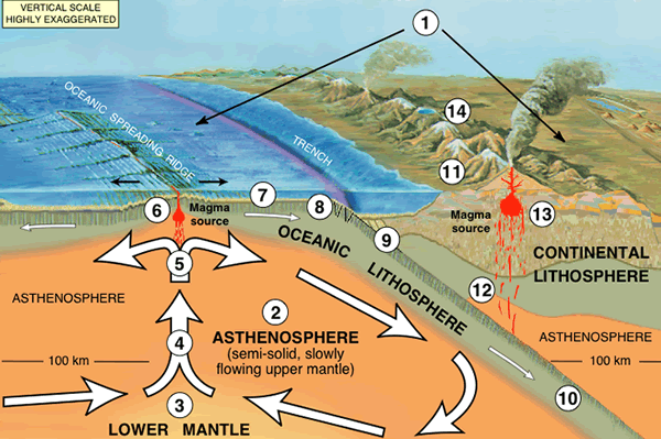 Tectonics explained through convection |
|---|---|---|
 South America and Africa once joined together |  Alfred Wegner (1880-1930) |  Map of the sea floor |
 Types of Plate boundaries |  Pangea |
Have you ever wondered why mountains form? Or why large valleys on the sea floor can exist? The answer lies within the study of plate tectonics. This theory developed by Alfred Wegner in 1912 has shaped our understanding of the earth, its origins, and the journey it has been on for five billion years.
Plate tectonics is defined as the theory suggesting that the Earth's shell is a rocky and thin crust divided into "plates" or sections. Just like a puzzle piece, these sections fit together, however, force to moves the plates away from each other due to the constant convection of the Earth's inner core.
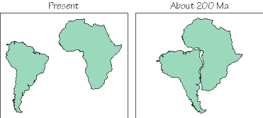
For centuries, people have noticed the similarities in the shape of the continents - especially in South America and Africa. It seemed as if these continents had once fit together - however, the absurdity of something so large such as a continent moving was the attitude that continued. that is until a geologist named Alfred Wener came along proposing the idea that all the continents once fit together into one large "supercontinent" he named Pangea (Greek for "all lands"). He proved that there once were glaciers covering places such as India that now live in such a warm place close to the equator. This climatic evidence supported the idea that India was once in another location - somewhere cold and much farther away from the equator. Although his discoveries of climatic evidence, similar fossils (such as in South America and Africa), landscapes (such as the Appalachines and Scottish Highlands) and soil composition posed deeming evidence of his theory, his explanation of how these continents could've moved lacked satisfaction and his work went unacknowledged by most of the scientific community.
It wasn't until the 1960's when Alfred Wegner's theory became a more accepted idea when Arthur Holmes came up with the idea of thermal convection. This theory proposed that the crusts are pulled back into the earth's core due to the temperature difference between the cool outside, and the hot inside of the core. The cooled off plates continuously are forced down into the molten core, and this process repeats over and over again.
In addition to this, the discovery of underwater mountains, valley, volcanoes etc. due to the invention of underwater radars during the Second World War, convinced more and more people of this once absurd theory. They discovered a variety of boundaries between the plates - causing these obscure underwater landscapes. The three types of boundaries - convergent, divergent and transform.
Through modern research, scientists have now predicted that plate tectonics began around 3.5 billion years ago. The earth's interior started to run out of radioactive elements to burn, and due to this stable convection could occur. As the crust began to be pulled down, and then pushed back to the top, it started to break apart the crust into smaller sections.
Over 500 million years, the crust began to develop into plates. Once these plates were established, the three types of boundaries convergent, divergent and transform occured. This caused the formation of landscapes.
Throughout time, these plates continued to break apart and collide through a variety of stages and forms. Scientists can predict these movements using computer simulations as well as climatic data. For example, it has been proven that India once was in a very cold climate, despite the fact that it is not positioned so close to the equator.
Around 200 million years ago, Pangea was created in which all the continents were joined. Soon, India and Antarctica, South America and Africa started to separate due to this constant movement of plates, as the continents began to separate from one another and form the seven continents we know today.
Scientists have been able to develop a map of plate tectonics discovering that there are seven major plates - North American, South American, African, Eurasian, Australian, Antarctic and Pacific as well as six secondary plates - Nazca, Carribean, Cocos, Indian, Juan de Fuca and the Philippine plates.
It is predicted that at some point, the continents will all join and form a supercontinent once again. Although this may not happen in our lifetimes, it is a compelling and intriguing idea that makes you wonder - what will earth look like in the future as it continues on its journey through time.